Site Planning and Design
These examples illustrate the use of manual and early computer cartography that were employed to conduct a site suitability analysis, also know as development suitability analysis.
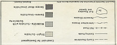
The Development Suitability Maps for Monmouth County were digitized in an early version of ArcInfo -ESRI, and the Development Suitability map for Somerset County was prepared by drawing soil boundaries on a sheet of mylar which was then used as a base for the application of screen-tone overlays to represent different levels of development constraints.
Both processes required the use of large amounts of information to identify the most suitable soil types which was accomplished by assessing their suitability of slopes, drainages, and other local characteristics. However, while the computerized maps can be updated rapidly and indefinitely to include such dynamic information, the manual cartographic processes produce static maps which are difficult to maintain to display new information.
Also, the screen-tones that were applied to the original base map mylar became brittle; shrinking and breaking some small slivers of Zip.A.Tone material which leaves many polygons without information about their soil cover types and suitability classifications.


AutoCad - Wetlands Delineation
